References to Eptakomi in historical maps and documents.
1878. Illustrated
London News.
The international news periodical records a
local dispute at Eptakomi under the title
"British Kaimakan hear
an assault case at Hepta-Khumi" The scene
depicts the scene at the village of Eftakomi,
when a case of assault was brought by the
parents of a peasant girl, before the British
kaimakam. The occasion was illustrated as a fine
line drawing.
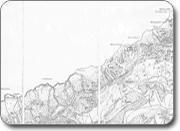
1880. First Survey map of Cyprus.
The first modern map of Cyprus was produced with the
arrival of British administration in 1878. The map was
surveyed under the direction of Kitchener using
trigonometric surveying techniques and printed at a
scale of 1 inch to the mile.
Eptakomi is clearly shown together with it’s
church just to the south of the village centre.
This map also shows the chapel of Ayios Epiphanios
3 miles to the north east of the village centre, which
was a ruin even at that time.
The landscape is illustrated in detail for the first
time and includes many local features of the Eptakomi
area:
Mountains and hilltops
Yiouti Vouno
Drakonda
Titsiro Vouno (hilltop)
River valleys
Klima Potamos
Meliona Potamos
Linarovrochos Potamos
Elevation and heights
Kampana crags - 831 and 811 feet
Kavalaropetra - 1049 feet
Village church – 414 feet
Coastal rocks and reefs
Skaloes Nisha
Serrios Nisha
Koutsopetri
The map also shows the ruins at Galounia, to the west of
Eptakomi on the north coast. This is considered by some
historians including to be the ancient site of Αχαιών Ακτή, the landing place of Teucer who founded Salamis.