References to Eptakomi in historical maps and documents.
The map position of 'Amtara' (Kantara) is not accurate,
however both Kantara and Akanthou were historic sites
well known to early map-makers. Giovanni Mariti in
Travels Through Cyprus Syria and Palestine (1792) says
"On this coast, towards the east from Cerines (Kyrenia)
there are also the villages of Amtara (Kantara) and
Accatu (Akanthou)".
'Cada' is more problematic and may reflect the sound of
a place name starting 'Kata', such as Katalimmata, a
forest area just to the south of Eptakomi.
What remain are a number of unnamed chapel / place
symbols in the general position where Eptakomi would be
expected (to the east of Davlos and to the west of
Platanisso). These are shown ringed in blue (image 1
detail) and fall into the geographic categories
mentioned earlier – those that lie near the sea on the
north coast and those that are clearly marked as south
of the mountain ridge.
So, without mentioning Eptakomi by name, this map of
1573 is probably the earliest to show the village’s
founding community sites.
1754.
"Drummond’s Travels",
Alexander Drummond.
Drummond was British consul at Aleppo from 1754
to 1756. In his volume he not only records
Eptakomi on a map for the first time but also
mentions it in his text.
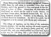
After leaving Kantara castle, he writes
"The greatest part of
the country is extremely pleasant, particularly
from Eftakomi to Platonissa, where rising
grounds covered with wood, and opening glades,
form an agreeable contrast: from the tops of the
low hills about Lionarissa the plains and
gardens delight the eye…"
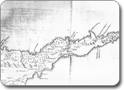
Drummond’s map also indicates his view of the
location of classical Aphrodisium, to the north
of Komi Kebir and to the west of Eptakomi.
Later
writers suchas Hogarth
consider that Aphrodisium
lies further west near Akanthou and that this site is
more likely to be Teucer's landing spot (Αχαιών Ακτή).